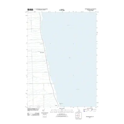
2011 Map of Richmondville
USGS Topo · Published 2011About this map
Lake Huron dominates the eastern expanse of this Sanilac County coastline, where the small lakeside communities of Richmondville and Forester are situated. The landscape is defined by several drainage systems that flow eastward toward the lake, including Elk Creek, Big Gully Creek, Indian Creek, and Cherry Creek. This topographic survey shows a sparse, rural settlement pattern characteristic of the Michigan Thumb, with a grid of local roads like State Rd and Ridge Rd providing access to the interior. For those researching local families, the Forester Township Cemetery is a prominent landmark located near the southern boundary, reflecting the established history of the township. The map details the transition from the upland agricultural areas down to the narrow shoreline, illustrating the intersection of natural waterways and local infrastructure.
Find a feature on this map
23 named features on this map. Tap any name to fly to it.
Don’t see what you’re looking for? This feature index may not catch every label — zoom into the map to look around manually.
Map Details
Editions of this 2011 Richmondville Map
This is the sole edition of this map. No revisions or reprints were ever made.
Other maps of this area

1954 · Flint
USGS Topo · 1:250,000

1958 · Flint
USGS Topo · 1:250,000

1963 · Forestville
USGS Topo · 1:24,000

1963 · Ruth
USGS Topo · 1:24,000

1963 · Port Sanilac
USGS Topo · 1:24,000

1963 · Deckerville
USGS Topo · 1:24,000

1963 · Richmondville
USGS Topo · 1:24,000
1963 · Carsonville
USGS Topo · 1:24,000

1984 · Harbor Beach
USGS Topo · 1:100,000

1984 · Croswell
USGS Topo · 1:100,000