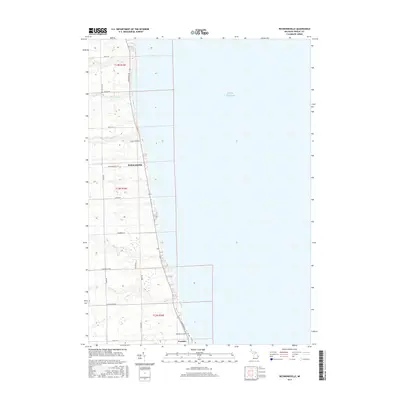
2017 Map of Richmondville
USGS Topo · Published 2017About this map
Lake Huron shoreline defines the eastern edge of this Michigan landscape, where small coastal settlements sit along the bluff line in Sanilac County. The community of Richmondville serves as a focal point in the central portion of the map, while Forester is situated to the south near the Forester Township Cem. The drainage pattern is characterized by numerous small tributaries, including Big Gully Cr, Indian Cr, and Big Cr, which carve their way toward the lake across a grid of agricultural land. The transportation network is built upon a strict rectangular system, with primary thoroughfares like Lakeshore Rd and Ridge Rd following the natural contours and section lines of T13N R16E and adjacent townships. This 2017 survey reflects the enduring rural character of the Thumb region, illustrating the relationship between the elevated lake bluffs and the interior farmland.
Find a feature on this map
28 named features on this map. Tap any name to fly to it.
Don’t see what you’re looking for? This feature index may not catch every label — zoom into the map to look around manually.
Map Details
Editions of this 2017 Richmondville Map
This is the sole edition of this map. No revisions or reprints were ever made.
Other maps of this area

1954 · Flint
USGS Topo · 1:250,000

1958 · Flint
USGS Topo · 1:250,000

1963 · Forestville
USGS Topo · 1:24,000

1963 · Ruth
USGS Topo · 1:24,000

1963 · Port Sanilac
USGS Topo · 1:24,000

1963 · Deckerville
USGS Topo · 1:24,000

1963 · Richmondville
USGS Topo · 1:24,000
1963 · Carsonville
USGS Topo · 1:24,000

1984 · Harbor Beach
USGS Topo · 1:100,000

1984 · Croswell
USGS Topo · 1:100,000