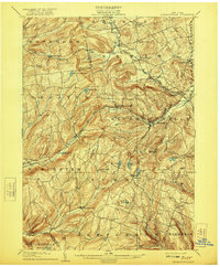
1904 Map of Richmondville
USGS Topo · Published 1921About this map
The Delaware and Hudson RR cuts a vital corridor through the high country of Schoharie and Otsego counties, following the valley of the Schenevus Creek and the Hudson River and Delaware Creek. At this turn-of-the-century moment, the landscape is defined by its small, specialized agricultural hubs and crossroad hamlets. Major rail-served towns like Richmondville and Worcester show established street grids and industrial footprints, while more remote upland communities like Lutheranville, Summit, and Charlotteville are connected by a dense web of overland roads.
Find a feature on this map
62 named features on this map. Tap any name to fly to it.
Don’t see what you’re looking for? This feature index may not catch every label — zoom into the map to look around manually.
Map Details
Editions of this 1904 Richmondville Map
5 editions found

Other maps of this area

1896 · Fonda
USGS Topo · 1:62,500

1898 · Fonda
USGS Topo · 1:62,500

1898 · Canajoharie
USGS Topo · 1:62,500

1898 · Schoharie
USGS Topo · 1:62,500

1900 · Canajoharie
USGS Topo · 1:62,500

1900 · Schoharie
USGS Topo · 1:62,500

1901 · Gilboa
USGS Topo · 1:62,500

1902 · Canajoharie
USGS Topo · 1:62,500

1902 · Fonda
USGS Topo · 1:62,500

1903 · Gilboa
USGS Topo · 1:62,500