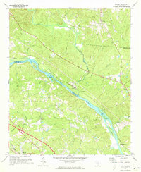
1971 Map of Richtex
USGS Topo · Published 1973About this map
The Broad River and Little River converge in this riverine landscape at the border of Fairfield and Richland counties. The settlement of Richtex sits at the junction of the Southern railroad and the river, while smaller communities like Littleton and Bookman are scattered along the rail line and rural roads. The area’s industrial activity is evident in the several extractive sites, including Claypits near the rail line and a Sandpit and Gravel Pit further north. Cultural history is anchored by numerous country churches and family burial grounds, such as Zion Pilgrim Ch, St Pauls Ch, and Gibson Cem. The river itself is defined by topographic features like Freshley Shoals, Haltiwanger Island, and Bookman Shoals, illustrating the natural hazards and geography that dictated early crossing points like Ashley Bridge and Browns Bridge.
Find a feature on this map
51 named features on this map. Tap any name to fly to it.
Don’t see what you’re looking for? This feature index may not catch every label — zoom into the map to look around manually.
Map Details
Editions of this 1971 Richtex Map
3 editions found
Other maps of this area

1904 · Columbia
USGS Topo · 1:125,000

1941 · Spartanburg
USGS Topo · 1:250,000

1946 · Irmo
USGS Topo · 1:24,000

1947 · Columbia North
USGS Topo · 1:24,000

1947 · Richtex
USGS Topo · 1:24,000

1948 · Irmo
USGS Topo · 1:24,000

1948 · Columbia North
USGS Topo · 1:24,000

1949 · Richtex
USGS Topo · 1:24,000

1949 · Irmo NE
USGS Topo · 1:24,000

1953 · Spartanburg
USGS Topo · 1:250,000