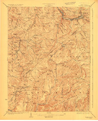
1923 Map of Richwood
USGS Topo · Published 1923About this map
Richwood stands at the confluence of the Cherry River and its forks, serving as a hub for the industrial and timber activity along the Baltimore and Ohio RR during the early 1920s. This survey, conducted by E. I. Ireland and other engineers, reveals a landscape defined by sharp ridges and a dense network of mountain schools and small settlements. The border between Nicholas and Greenbrier Counties cuts through these highlands, connecting coal-rich areas around Marfrance and Quinwood to the north.
Find a feature on this map
155 named features on this map. Tap any name to fly to it.
Don’t see what you’re looking for? This feature index may not catch every label — zoom into the map to look around manually.
Map Details
Editions of this 1923 Richwood Map
3 editions found
Other maps of this area

1887 · Hinton
USGS Topo · 1:125,000

1887 · Lewisburg
USGS Topo · 1:125,000

1889 · Nicholas
USGS Topo · 1:125,000

1891 · Lewisburg
USGS Topo · 1:125,000

1891 · Nicholas
USGS Topo · 1:125,000

1891 · Huntersville
USGS Topo · 1:125,000

1892 · Hinton
USGS Topo · 1:125,000

1894 · Huntersville
USGS Topo · 1:125,000

1901 · Nicholas
USGS Topo · 1:125,000

1912 · Meadow Creek
USGS Topo · 1:48,000