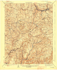
1939 Map of Richwood
USGS Topo · Published 1939About this map
Richwood and Quinwood anchor a landscape defined by the heavy timber and mining industries of West Virginia's central highlands. This 1930s era topography shows the Chesapeake and Ohio RR winding through the steep river valleys, connecting coal camps like Marfrance, Crichton, and Leslie. The density of community institutions in this rugged terrain is notable, with numerous small educational and spiritual centers such as Mountain Chapel, Nunnery Chapel, and the Snow Hill School serving the remote ridge-top and valley populations.
Find a feature on this map
151 named features on this map. Tap any name to fly to it.
Don’t see what you’re looking for? This feature index may not catch every label — zoom into the map to look around manually.
Map Details
Editions of this 1939 Richwood Map
2 editions found
Other maps of this area

1887 · Hinton
USGS Topo · 1:125,000

1887 · Lewisburg
USGS Topo · 1:125,000

1889 · Nicholas
USGS Topo · 1:125,000

1891 · Lewisburg
USGS Topo · 1:125,000

1891 · Nicholas
USGS Topo · 1:125,000

1891 · Huntersville
USGS Topo · 1:125,000

1892 · Hinton
USGS Topo · 1:125,000

1894 · Huntersville
USGS Topo · 1:125,000

1901 · Nicholas
USGS Topo · 1:125,000

1912 · Meadow Creek
USGS Topo · 1:48,000