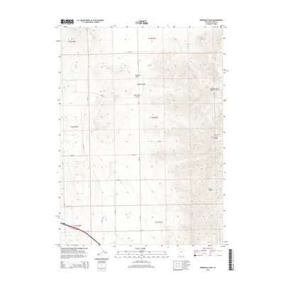
2014 Map of Ridgedale Pass
USGS Topo · Published 2014About this map
Blue Creek Valley and Pocatello Valley meet at the topographical threshold of Ridgedale Pass, defining a high-altitude agricultural and rangeland corridor in Box Elder County. This 2014 survey captures the organized grid of county roads, such as W 26400 N and W 25000 N, which navigate the basin floors between prominent rises. The eastern edge of the quadrangle is dominated by the steep ascent into the West Hills, where drainage systems like Portage Canyon, Broad Canyon, and the Left Hand Fork Middle Canyon carve deep into the slopes. The perennial course of Blue Cr winds through the valley bottoms, serving as a vital water source for the remote holdings and grazing lands that characterize this corner of northern Utah. This map effectively documents the intersection of precise modern section-line surveying with the enduring natural barriers of the Great Basin landscape.
Find a feature on this map
21 named features on this map. Tap any name to fly to it.
Don’t see what you’re looking for? This feature index may not catch every label — zoom into the map to look around manually.
Map Details
Editions of this 2014 Ridgedale Pass Map
This is the sole edition of this map. No revisions or reprints were ever made.
Other maps of this area

1954 · Pocatello
USGS Topo · 1:250,000

1954 · Brigham City
USGS Topo · 1:250,000

1958 · Pocatello
USGS Topo · 1:250,000

1958 · Brigham City
USGS Topo · 1:250,000

1962 · Brigham City
USGS Topo · 1:250,000

1968 · Grover Canyon
USGS Topo · 1:24,000

1968 · Samaria
USGS Topo · 1:24,000
1968 · Limekiln Knoll
USGS Topo · 1:24,000

1968 · Howell
USGS Topo · 1:24,000

1968 · Ridgedale Pass
USGS Topo · 1:24,000