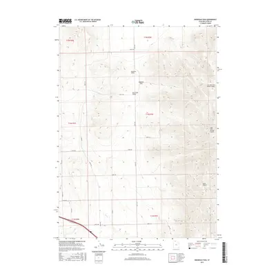
2017 Map of Ridgedale Pass
USGS Topo · Published 2017About this map
Pocatello Valley and Blue Creek Valley form the primary geographic focus of this northern Utah landscape, where high-elevation basins are separated by the prominent Ridgedale Pass. The area is characterized by a high-desert drainage system, most notably the seasonal course of Blue Cr and the complex relief of the surrounding West Hills. The terrain is deeply incised by several named drainages, including Broad Canyon, West Hills Portage Canyon, and Left Hand Fork Middle Canyon. A sparse network of range roads and the historic Indian Trl highlight the intersection of traditional routes and modern land management in this portion of Box Elder County. The cartography emphasizes the intricate contouring of the ridges and the specific township and range divisions that govern the land use across this part of the Intermountain West.
Find a feature on this map
26 named features on this map. Tap any name to fly to it.
Don’t see what you’re looking for? This feature index may not catch every label — zoom into the map to look around manually.
Map Details
Editions of this 2017 Ridgedale Pass Map
This is the sole edition of this map. No revisions or reprints were ever made.
Other maps of this area

1954 · Pocatello
USGS Topo · 1:250,000

1954 · Brigham City
USGS Topo · 1:250,000

1958 · Pocatello
USGS Topo · 1:250,000

1958 · Brigham City
USGS Topo · 1:250,000

1962 · Brigham City
USGS Topo · 1:250,000

1968 · Grover Canyon
USGS Topo · 1:24,000

1968 · Samaria
USGS Topo · 1:24,000
1968 · Limekiln Knoll
USGS Topo · 1:24,000

1968 · Howell
USGS Topo · 1:24,000

1968 · Ridgedale Pass
USGS Topo · 1:24,000