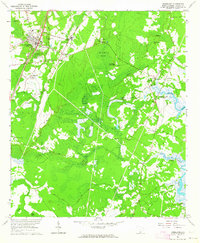
1961 Map of Ridgeland
USGS Topo · Published 1964About this map
The town of Ridgeland and its surrounding Lowcountry landscape are defined here by a dense network of historical plantations and religious sites during the early 1960s. South of the municipal center, the settlement of Grahamville serves as a hub for local history, featuring the Holy Trinity Ch and Grahamville Cem. This area preserves significant military heritage, with several Entrenchments and a specific Civil War Entrenchment noted near Honey Hill.
Find a feature on this map
58 named features on this map. Tap any name to fly to it.
Don’t see what you’re looking for? This feature index may not catch every label — zoom into the map to look around manually.
Map Details
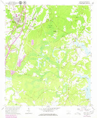
Editions of this 1961 Ridgeland Map
2 editions found
Other maps of this area

1918 · Yemassee
USGS Topo · 1:62,500

1919 · Pineland
USGS Topo · 1:62,500

1920 · Hardeeville
USGS Topo · 1:62,500

1920 · Okatie
USGS Topo · 1:62,500

1942 · Okatie
USGS Topo · 1:62,500

1943 · Pineland
USGS Topo · 1:62,500

1943 · Hardeeville
USGS Topo · 1:62,500
1943 · Yemassee
USGS Topo · 1:62,500

1947 · Savannah
USGS Topo · 1:250,000

1948 · Savannah
USGS Topo · 1:250,000