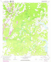
1961 Map of Ridgeland
USGS Topo · Published 1979About this map
Civil War Entrenchments near Honey Hill highlight the strategic importance of this South Carolina landscape, which remained defined by its plantation heritage and swampy terrain into the late twentieth century. The community of Ridgeland serves as the primary hub, where the Seaboard Coast Line and Ridgeland Municipal Airport parallel the developing corridor of Interstate 95. To the east, the map reveals a dense network of spiritual and family sites, including Annie York Ch, First Euhaw Ch, and the Heyward Cem near Old House. Large landholdings like Good Hope Plantation and Strawberry Hill Plantation occupy the higher ground between the Honey Hill Swamp and the tidal reaches of Hazzard Creek. The distribution of rural churches and cemeteries across Grahamville and Nevadun provides a detailed view of the localized settlement patterns characteristic of Jasper County before modern suburban expansion.
Find a feature on this map
67 named features on this map. Tap any name to fly to it.
Don’t see what you’re looking for? This feature index may not catch every label — zoom into the map to look around manually.
Map Details
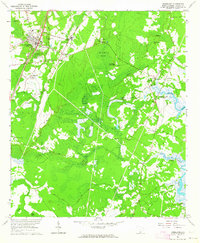
Editions of this 1961 Ridgeland Map
2 editions found
Other maps of this area

1918 · Yemassee
USGS Topo · 1:62,500

1919 · Pineland
USGS Topo · 1:62,500

1920 · Hardeeville
USGS Topo · 1:62,500

1920 · Okatie
USGS Topo · 1:62,500

1942 · Okatie
USGS Topo · 1:62,500

1943 · Pineland
USGS Topo · 1:62,500

1943 · Hardeeville
USGS Topo · 1:62,500
1943 · Yemassee
USGS Topo · 1:62,500

1947 · Savannah
USGS Topo · 1:250,000

1948 · Savannah
USGS Topo · 1:250,000