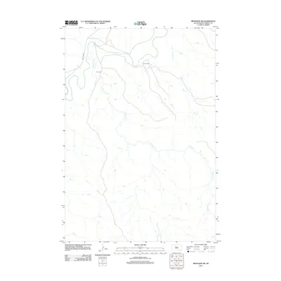
2012 Map of Ridgeview NW
USGS Topo · Published 2012About this map
The Moreau River meanders across this Dewey County landscape, carving a wide valley through the plains of District 4. This 2012 survey highlights a rural ranching environment where water sources like Cottonwood Cr and Bull Cr dictate the layout of local properties. Named family holdings, such as Ewing Ranch and Gunville Ranch, are positioned near these critical drainages. The area is intersected by local thoroughfares, most notably On The Tree Rd, which provides access to these remote ranching operations. The mapping reflects a modern era of land management on the Cheyenne River Reservation, focusing on the essential relationship between the hydrology of the river breaks and the isolated settlements that support the regional cattle industry.
Find a feature on this map
6 named features on this map. Tap any name to fly to it.
Don’t see what you’re looking for? This feature index may not catch every label — zoom into the map to look around manually.
Map Details
Editions of this 2012 Ridgeview NW Map
This is the sole edition of this map. No revisions or reprints were ever made.
Other maps of this area

1951 · Ridgeview NW
USGS Topo · 1:24,000

1951 · Ridgeview NE
USGS Topo · 1:24,000

1952 · Whitehorse
USGS Topo · 1:24,000

1952 · Parade NE
USGS Topo · 1:24,000

1952 · Glencross SE
USGS Topo · 1:24,000

1953 · McIntosh
USGS Topo · 1:250,000

1958 · McIntosh
USGS Topo · 1:250,000

1978 · Little Moreau Lake
USGS Topo · 1:24,000
1981 · Parade
USGS Topo · 1:24,000
1981 · Ridgeview
USGS Topo · 1:24,000