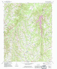
1968 Map of Ridgeville
USGS Topo · Published 1994About this map
Ridgeville and the surrounding countryside of the Piedmont are defined by a network of rural settlements and family landmarks along the border of Caswell and Person Counties. The landscape is carved by the winding paths of Hyco Creek and its many tributaries, including Panther Creek and Sugartree Creek, which shape the local topography. This 1968 survey, later updated with mid-1990s revisions, reveals a community anchored by numerous country churches, such as Lea Bethel Ch, Allens Chapel, and Warren Chapel, indicating a deeply rooted social and spiritual geography.
Find a feature on this map
34 named features on this map. Tap any name to fly to it.
Don’t see what you’re looking for? This feature index may not catch every label — zoom into the map to look around manually.
Map Details
Editions of this 1968 Ridgeville Map
2 editions found
Other maps of this area

1953 · Greensboro
USGS Topo · 1:250,000

1954 · Greensboro
USGS Topo · 1:250,000

1962 · Greensboro
USGS Topo · 1:250,000

1966 · Greensboro
USGS Topo · 1:250,000

1967 · Cedar Grove
USGS Topo · 1:24,000

1968 · Leasburg
USGS Topo · 1:24,000

1968 · Caldwell
USGS Topo · 1:24,000

1968 · Ridgeville
USGS Topo · 1:24,000

1968 · Hurdle Mills
USGS Topo · 1:24,000
1968 · Olive Hill
USGS Topo · 1:24,000