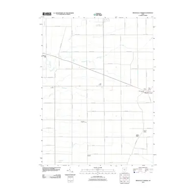
2010 Map of Ridgeville Corners
USGS Topo · Published 2010About this map
Ridgeville Corners serves as the primary hub for this northwestern Ohio landscape, characterized by a dense grid of township and county roads that support a tradition of rural agricultural life. The map reveals a cluster of community institutions including the Ridgeville Corners Post Office and nearby Saint Peter Cemetery. This region is defined by its numerous small burial grounds and parish sites that point to the settlement history of the local townships, such as the Saint Marks Lutheran Cemetery and the Domersville Cemetery located near the southern edge. The terrain is marked by subtle drainage patterns where Owl Creek, Coon Creek, and Brush Creek thread through the fields, while the small settlement of Adams Ridge sits to the east. The intersection of local infrastructure and long-standing family-named roads like Domersville Rd and Moser Rd provides a clear view of the area's modern rural composition.
Find a feature on this map
57 named features on this map. Tap any name to fly to it.
Don’t see what you’re looking for? This feature index may not catch every label — zoom into the map to look around manually.
Map Details
Editions of this 2010 Ridgeville Corners Map
This is the sole edition of this map. No revisions or reprints were ever made.
Other maps of this area

1907 · Defiance
USGS Topo · 1:62,500

1908 · Napoleon
USGS Topo · 1:62,500

1909 · Defiance
USGS Topo · 1:62,500

1911 · Wauseon
USGS Topo · 1:62,500

1913 · Wauseon
USGS Topo · 1:62,500

1913 · Alvordton
USGS Topo · 1:62,500

1943 · Wauseon
USGS Topo · 1:62,500

1944 · Alvordton
USGS Topo · 1:62,500

1953 · Fort Wayne
USGS Topo · 1:250,000

1956 · Fort Wayne
USGS Topo · 1:250,000