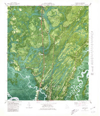
1980 Map of Ridgeville
USGS Topo · Published 1980About this map
Darien and the coastal lowlands of McIntosh County are captured here in an era defined by a complex network of waterways and marshlands. The landscape is dominated by the massive Buffalo Swamp to the west and the winding course of the Altamaha River to the south. This 1980 orthophotomap provides a rare hybrid view of the region's topography overlaid on aerial imagery, highlighting the distinct boundaries between the cultivated lands around Ridgeville and the expansive Altamaha Waterfowl Management Area. Local history is preserved through the numerous family and community landmarks, including Oglethorpe Academy and Ashantilly. The map details a landscape where life was oriented toward the water, from the Marina near Bradwell Island to the many scattered cemeteries like Hutchinson Cem and King Cem, which serve as markers for long-established coastal families.
Find a feature on this map
67 named features on this map. Tap any name to fly to it.
Don’t see what you’re looking for? This feature index may not catch every label — zoom into the map to look around manually.
Map Details
Editions of this 1980 Ridgeville Map
This is the sole edition of this map. No revisions or reprints were ever made.
Other maps of this area

1918 · Everett City
USGS Topo · 1:62,500

1920 · Sapelo River
USGS Topo · 1:62,500

1920 · Everett City
USGS Topo · 1:62,500

1921 · Darien
USGS Topo · 1:62,500

1943 · Ludowici
USGS Topo · 1:62,500

1943 · Sapelo River
USGS Topo · 1:62,500

1944 · Everett City
USGS Topo · 1:62,500

1945 · Sapelo River
USGS Topo · 1:62,500

1946 · Brunswick
USGS Topo · 1:250,000

1948 · Brunswick
USGS Topo · 1:250,000