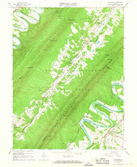
1966 Map of Rileyville
USGS Topo · Published 1968About this map
The Shenandoah River and its South Fork dominate this mid-century portrait of the valley, winding through the George Washington National Forest. The landscape is defined by the massive ridges of Powell Mountain and Massanuten Mountain, separated by the steep drainage of Passage Creek. Small farming and river communities like Seven Fountains, Detrick, and Rileyville are connected by narrow valley roads and the Norfolk and Western railroad corridor. Notable local landmarks include the Woodstock Lookout Tower and industrial sites like Goods Mill and a Sand and Gravel Pit near the river. For family historians, the map identifies several rural congregations and burial sites, including Trinity Ch, White Chapel, and the Munch Cem, illustrating the deep-rooted settlement patterns within the gaps and river bottoms of the Blue Ridge foothills.
Find a feature on this map
52 named features on this map. Tap any name to fly to it.
Don’t see what you’re looking for? This feature index may not catch every label — zoom into the map to look around manually.
Map Details
Editions of this 1966 Rileyville Map
4 editions found
Other maps of this area

1892 · Woodstock
USGS Topo · 1:125,000

1893 · Luray
USGS Topo · 1:125,000

1905 · Luray
USGS Topo · 1:125,000

1923 · Edinburg
USGS Topo · 1:62,500

1929 · Stony Man
USGS Topo · 1:48,000

1933 · Stony Man
USGS Topo · 1:62,500

1942 · Mt Jackson
USGS Topo · 1:62,500

1946 · Mt Jackson
USGS Topo · 1:62,500

1947 · Mt Jackson
USGS Topo · 1:62,500

1947 · Strasburg
USGS Topo · 1:62,500