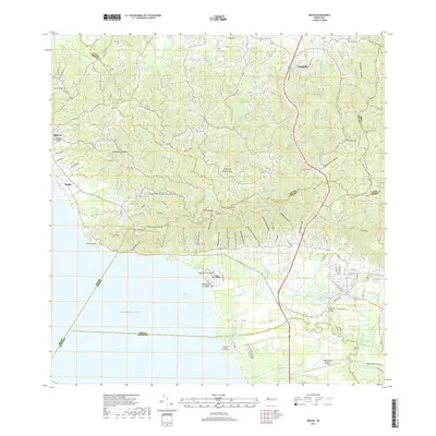
2018 Map of Rincon
USGS Topo · Published 2018About this map
The western coastline of Puerto Rico meets the Caribbean Sea at Punta Cadena, where the foothills of La Cadena descend toward the shore. This topographic survey captures the area as it appeared in 2018, defined by the drainage of numerous streams including Quebrada Piletas and Quebrada Grande de Calvache. The coastal settlements of Rincón and Stella sit northwest of the Cerros de San Francisco, while to the south, the landscape transitions into the alluvial plains of the Río Grande de Añasco. This southern sector is marked by coastal wetlands such as Ciénaga El Guayabal and the presence of the Eugenio María de Hostos Airport. Significant for genealogy and local history, the map locates the Cementerio Municipal de Rincón and the Cementerio Municipal de Añasco near the urban centers of La Playa and Luyando.
Find a feature on this map
52 named features on this map. Tap any name to fly to it.
Don’t see what you’re looking for? This feature index may not catch every label — zoom into the map to look around manually.
Map Details
Editions of this 2018 Rincon Map
This is the sole edition of this map. No revisions or reprints were ever made.
Other maps of this area

1937 · Aguadilla
USGS Topo · 1:20,000

1937 · Moca
USGS Topo · 1:20,000

1938 · Alto Sano
USGS Topo · 1:20,000

1939 · Mayaguez
USGS Topo · 1:30,000

1941 · Moca
USGS Topo · 1:30,000

1941 · Rincon
USGS Topo · 1:30,000

1941 · Rincon
USGS Topo · 1:30,000

1941 · Rosario
USGS Topo · 1:30,000

1942 · Moca
USGS Topo · 1:30,000

1942 · Central La Plata
USGS Topo · 1:30,000
Featured Places
- Añasco
- Sector Los Ríos, Añasco
- Urbanización Las Casonas, Aguada
- Sector Pilar Figueroa, Aguada
- Sector Rubí, Aguada