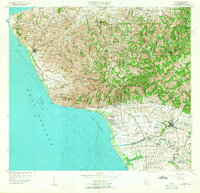
1955 Map of Rincon
USGS Topo · Published 1958About this map
Rincón and the westernmost tip of Puerto Rico are defined by the sharp transition from the Cerros de San Francisco to the coastal plains of the Bahía de Añasco. This 1950s era survey captures an agricultural landscape dominated by numerous sugar colonies, such as Colonia Libertad and Colonia Trinidad, scattered across the alluvial lowlands. The industrial presence of Central Igualdad near the Río Cañas illustrates the regional importance of the sugar industry, while the Faro at Punta Jiguero marks the entrance to the Mona Passage. Interior elevations like Pico Atalaya overlook a network of barrios including Guanábano and Piedras Blancas, where local life centered around rural schools like the Escuela Segunda Unidad de Juntas. The map traces the coastal geography from the reef at Arrecife Peregrina to the complex wetlands of Ciénaga El Guayabal.
Find a feature on this map
85 named features on this map. Tap any name to fly to it.
Don’t see what you’re looking for? This feature index may not catch every label — zoom into the map to look around manually.
Map Details
Editions of this 1955 Rincon Map
This is the sole edition of this map. No revisions or reprints were ever made.
Other maps of this area

1937 · Aguadilla
USGS Topo · 1:20,000

1937 · Moca
USGS Topo · 1:20,000

1938 · Alto Sano
USGS Topo · 1:20,000

1939 · Mayaguez
USGS Topo · 1:30,000

1941 · Moca
USGS Topo · 1:30,000

1941 · Rincon
USGS Topo · 1:30,000

1941 · Rincon
USGS Topo · 1:30,000

1941 · Rosario
USGS Topo · 1:30,000

1942 · Moca
USGS Topo · 1:30,000

1942 · Central La Plata
USGS Topo · 1:30,000