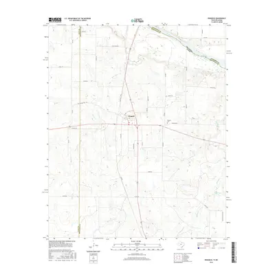
2016 Map of Ringgold
USGS Topo · Published 2016About this map
Ringgold serves as the central hub of this Montague County landscape, situated at the intersection of several primary local thoroughfares. The town layout is defined by its proximity to the border with Oklahoma, where the Red River carves the northern boundary of the state. This area is characterized by a dense network of watercourses, including Beaver Cr, Buzzardwing Cr, and Belknap Cr, which drain the surrounding terrain toward the river valley. Genealogists and local historians can locate the Ringgold Cem east of the main settlement and trace the path of Battle Axe School Rd in the southeastern portion of the quadrangle. The map reveals a rural structure where name-bearing roads like Staley Rd and Dutton Rd provide access to the various drainage basins and family-held tracts of the Red River valley.
Find a feature on this map
39 named features on this map. Tap any name to fly to it.
Don’t see what you’re looking for? This feature index may not catch every label — zoom into the map to look around manually.
Map Details
Editions of this 2016 Ringgold Map
This is the sole edition of this map. No revisions or reprints were ever made.
Other maps of this area

1905 · Montague
USGS Topo · 1:125,000

1954 · Sherman
USGS Topo · 1:250,000

1954 · Wichita Falls
USGS Topo · 1:250,000

1956 · Henrietta
USGS Topo · 1:62,500

1958 · Wichita Falls
USGS Topo · 1:250,000

1958 · Sherman
USGS Topo · 1:250,000

1960 · Buzzard Roost Knob
USGS Topo · 1:24,000

1961 · Stoneburg
USGS Topo · 1:24,000
1968 · Bellevue
USGS Topo · 1:24,000
1968 · Terral
USGS Topo · 1:24,000