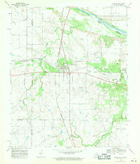
1968 Map of Ringgold
USGS Topo · Published 1971About this map
The Red River marks the northern border of this North Texas landscape, where the confluence of the Chicago Rock Island and Pacific railroad and major roadways defines the hub at Ringgold. Surveyed in the late 1960s, the map reveals a region transitioning between pastoral ranching and energy extraction. The southern portion of the quadrangle is dominated by the Worsham Oil Field, indicating the importance of petroleum to the local economy of Montague and Clay Counties. Local history is anchored by several small burial grounds, including Ringgold Cem and Boren Cem, while the natural drainage is defined by the winding paths of Beaver Creek and Belknap Creek. This detailed topographical record documents a specific era of rural Texas development, capturing the balance between family-named landmarks like Silver and the industrial footprint of regional railroads and oil production.
Find a feature on this map
15 named features on this map. Tap any name to fly to it.
Don’t see what you’re looking for? This feature index may not catch every label — zoom into the map to look around manually.
Map Details
Editions of this 1968 Ringgold Map
This is the sole edition of this map. No revisions or reprints were ever made.
Other maps of this area

1905 · Montague
USGS Topo · 1:125,000

1954 · Sherman
USGS Topo · 1:250,000

1954 · Wichita Falls
USGS Topo · 1:250,000

1956 · Henrietta
USGS Topo · 1:62,500

1958 · Wichita Falls
USGS Topo · 1:250,000

1958 · Sherman
USGS Topo · 1:250,000

1960 · Buzzard Roost Knob
USGS Topo · 1:24,000

1961 · Stoneburg
USGS Topo · 1:24,000
1968 · Bellevue
USGS Topo · 1:24,000
1968 · Terral
USGS Topo · 1:24,000