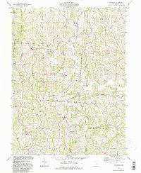
1994 Map of Ringgold
USGS Topo · Published 1998About this map
The Wolf Creek State Wildlife Area dominates the central landscape of this Morgan County region, where the deep dissection of the Allegheny Plateau is carved by the West Branch Wolf Creek and its many tributaries. This 1990s record of the terrain preserves the locations of several small ridge-top and valley settlements, including Ringgold, Mountville, and Elliott Crossroads. The map provides a detailed view of rural life through its numerous country churches and cemeteries, such as Mt Olive Ch Cem and Pleasant Hill Ch Cem, which are essential for genealogical research in this part of Ohio.
Find a feature on this map
42 named features on this map. Tap any name to fly to it.
Don’t see what you’re looking for? This feature index may not catch every label — zoom into the map to look around manually.
Map Details
Editions of this 1994 Ringgold Map
This is the sole edition of this map. No revisions or reprints were ever made.
Other maps of this area

1903 · Athens
USGS Topo · 1:62,500

1904 · Chesterhill
USGS Topo · 1:62,500

1905 · Athens
USGS Topo · 1:62,500

1906 · Chesterhill
USGS Topo · 1:62,500

1910 · Mc Connelsville
USGS Topo · 1:62,500

1911 · New Lexington
USGS Topo · 1:62,500

1947 · Columbus
USGS Topo · 1:250,000

1949 · Clarksburg
USGS Topo · 1:250,000

1956 · Clarksburg
USGS Topo · 1:250,000

1960 · Amesville
USGS Topo · 1:24,000