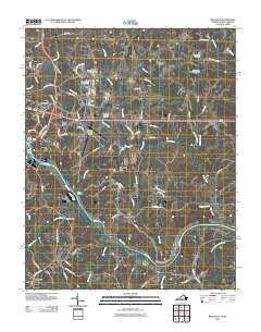
2011 Map of Ringgold
USGS Topo · Published 2011About this map
The Dan River serves as the central artery of this Piedmont landscape, winding through a region defined by its water-powered history and small agricultural settlements. In the early 21st century, the river's legacy is visible in the series of dams and industrial landmarks that line its course, including the Dan River Mills Noname Dam and the Grubb Dam. Near the North Carolina border, the settlement of Blanch and the site of Wallace Mill on Hogans Creek highlight the rural infrastructure that has persisted for generations.
Find a feature on this map
90 named features on this map. Tap any name to fly to it.
Don’t see what you’re looking for? This feature index may not catch every label — zoom into the map to look around manually.
Map Details
Editions of this 2011 Ringgold Map
This is the sole edition of this map. No revisions or reprints were ever made.
Other maps of this area

1923 · Danville
USGS Topo · 1:48,000

1925 · Danville
USGS Topo · 1:62,500

1952 · Milton
USGS Topo · 1:62,500

1953 · Greensboro
USGS Topo · 1:250,000

1954 · Greensboro
USGS Topo · 1:250,000

1956 · Milton
USGS Topo · 1:62,500

1962 · Greensboro
USGS Topo · 1:250,000

1964 · Mount Hermon
USGS Topo · 1:24,000
1964 · Blairs
USGS Topo · 1:24,000

1965 · Danville
USGS Topo · 1:24,000