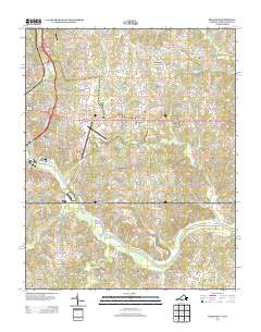
2013 Map of Ringgold
USGS Topo · Published 2013About this map
The Dan River snakes through the southern portion of this landscape, defining the topography near the Virginia and North Carolina border. The community of Ringgold anchors the northern section, surrounded by a network of local routes like Wilkerson Rd and Bright Leaf Rd. The proximity of transportation infrastructure is evident with the Danville Regional Airport and Buck Hollar Airport serving the area, while the suburban character of Green Acres and Lakewood contrasts with more rural southern stretches. Historically significant points such as Wallace Mill and the settlement of Mountain Hill provide anchors for local researchers. The southern reach of the quadrangle crosses into North Carolina, where the terrain is marked by numerous watercourses, including Coy Cr, Moon Cr, and Rattlesnake Cr, which drain into the main river valley near Blanch.
Find a feature on this map
107 named features on this map. Tap any name to fly to it.
Don’t see what you’re looking for? This feature index may not catch every label — zoom into the map to look around manually.
Map Details
Editions of this 2013 Ringgold Map
This is the sole edition of this map. No revisions or reprints were ever made.
Other maps of this area

1923 · Danville
USGS Topo · 1:48,000

1925 · Danville
USGS Topo · 1:62,500

1952 · Milton
USGS Topo · 1:62,500

1953 · Greensboro
USGS Topo · 1:250,000

1954 · Greensboro
USGS Topo · 1:250,000

1956 · Milton
USGS Topo · 1:62,500

1962 · Greensboro
USGS Topo · 1:250,000

1964 · Mount Hermon
USGS Topo · 1:24,000
1964 · Blairs
USGS Topo · 1:24,000

1965 · Danville
USGS Topo · 1:24,000