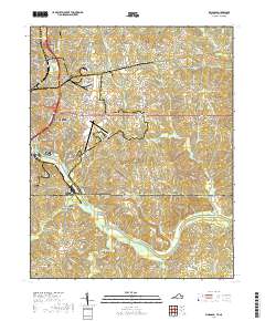
2019 Map of Ringgold
USGS Topo · Published 2019About this map
The Dan River snakes across the southern portion of this borderlands landscape, marking a topographically varied region where the Piedmont of Virginia meets North Carolina. Industrial and transport hubs define the western edge, where Danville and Glenwood sit near the Norfolk Southern rail line and the Danville Regional Airport. The settlement pattern follows old country roads and ridge lines, connecting established communities like Ringgold and Lakewood in Virginia to southern outposts such as Blanch and Providence across the state line. Smaller family and community landmarks are scattered throughout the hills, including Wallace Mill on Hogans Creek and the Mount Zion Cem in the northeast. The terrain is deeply dissected by a dense network of watercourses, such as Cane Creek and Fall Creek, which have shaped the local road network and settlement clusters at locations like Mountain Hill.
Find a feature on this map
133 named features on this map. Tap any name to fly to it.
Don’t see what you’re looking for? This feature index may not catch every label — zoom into the map to look around manually.
Map Details
Editions of this 2019 Ringgold Map
This is the sole edition of this map. No revisions or reprints were ever made.
Other maps of this area

1923 · Danville
USGS Topo · 1:48,000

1925 · Danville
USGS Topo · 1:62,500

1952 · Milton
USGS Topo · 1:62,500

1953 · Greensboro
USGS Topo · 1:250,000

1954 · Greensboro
USGS Topo · 1:250,000

1956 · Milton
USGS Topo · 1:62,500

1962 · Greensboro
USGS Topo · 1:250,000

1964 · Mount Hermon
USGS Topo · 1:24,000
1964 · Blairs
USGS Topo · 1:24,000

1965 · Danville
USGS Topo · 1:24,000