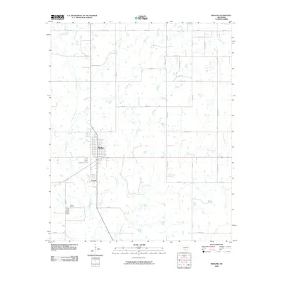
2009 Map of Ringling
USGS Topo · Published 2009About this map
Ringling and Cornish serve as the primary hubs of this Jefferson and Carter County landscape, appearing here at a time when the grid of rural section-line roads was well-established. The terrain is defined by a dendritic drainage network, with North Mud Creek and Post Oak Creek cutting through the countryside. Evidence of the region's industrial and social character is found in the naming of thoroughfares like Mobil Rd and Wirt Camp Rd, while local heritage is anchored by the Cornish Cemetery south of the primary settlement. The map reveals how the modern highway system interacts with earlier patterns of movement, showing residential and industrial clusters that follow the path of Pat Apala Blvd and other arterial routes. For those studying the evolution of Southern Oklahoma's rural communities, the map provides a clear picture of how land was partitioned and utilized during the first decade of the 2000s.
Find a feature on this map
40 named features on this map. Tap any name to fly to it.
Don’t see what you’re looking for? This feature index may not catch every label — zoom into the map to look around manually.
Map Details
Editions of this 2009 Ringling Map
This is the sole edition of this map. No revisions or reprints were ever made.
Other maps of this area

1901 · Addington
USGS Topo · 1:125,000

1901 · Ardmore
USGS Topo · 1:125,000

1918 · Ardmore
USGS Topo · 1:125,000

1957 · Ardmore
USGS Topo · 1:250,000

1963 · Ardmore
USGS Topo · 1:250,000

1969 · Healdton
USGS Topo · 1:24,000
1969 · Healdton SW
USGS Topo · 1:24,000
1969 · Fox
USGS Topo · 1:24,000
1974 · Orr
USGS Topo · 1:24,000

1974 · Ringling NW
USGS Topo · 1:24,000