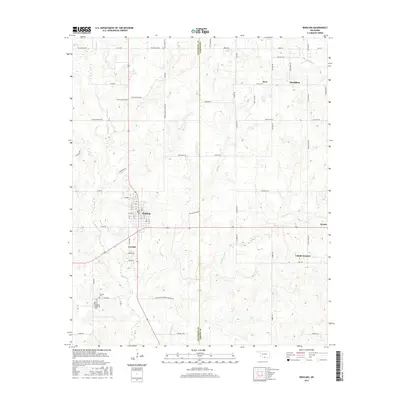
2016 Map of Ringling
USGS Topo · Published 2016About this map
Ringling and its neighboring community of Cornish dominate the western edge of this 2016 survey, while Healdton and Wirt anchor the eastern landscape. The area is defined by a dense network of local roads such as Doyle Dickey Blvd and Noble Crook Wade Blvd, alongside the Jefferson and Carter county line. For genealogists, the map identifies specific final resting places including Cornish Cem and Ringling Memorial Cem. The hydrology is characterized by numerous small drainage networks like Post Oak Cr, N Mud Cr, and Whisky Cr, which carve through the terrain between the primary settlements. Smaller locales such as Cobalt Junction and Zaneis appear along the road network, reflecting the long-established rural settlement patterns that persist in this part of Oklahoma.
Find a feature on this map
79 named features on this map. Tap any name to fly to it.
Don’t see what you’re looking for? This feature index may not catch every label — zoom into the map to look around manually.
Map Details
Editions of this 2016 Ringling Map
This is the sole edition of this map. No revisions or reprints were ever made.
Other maps of this area

1901 · Addington
USGS Topo · 1:125,000

1901 · Ardmore
USGS Topo · 1:125,000

1918 · Ardmore
USGS Topo · 1:125,000

1957 · Ardmore
USGS Topo · 1:250,000

1963 · Ardmore
USGS Topo · 1:250,000

1969 · Healdton
USGS Topo · 1:24,000
1969 · Healdton SW
USGS Topo · 1:24,000
1969 · Fox
USGS Topo · 1:24,000
1974 · Orr
USGS Topo · 1:24,000

1974 · Ringling NW
USGS Topo · 1:24,000