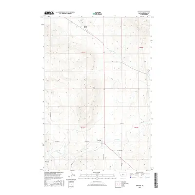
2017 Map of Ringling
USGS Topo · Published 2017About this map
Ringling and its surrounding ranchlands are situated in the high valleys of Meagher County, where the southern reaches of the Smith River watershed meet the drainage of Sixteenmile Cr. The settlement of Ringling serves as a central point in a landscape defined by expansive topography and intermittent watercourses like Lost Cr and Meadow Cr. Further north, Moss Agate sits near the headwaters of Agate Cr and the S Fork Smith River, while the isolated Horse Butte provides a prominent landmark between these small outposts. This area exhibits a typical Montana pattern of large-scale ranching and remote habitations, connected by a network of rural routes such as Sixteen Mile Rd and 51 Ranch Rd, which follow the contours of the drainage basins. Southward towards Moyne, the terrain shifts toward more intricate creek systems, reflecting the high-altitude water management essential for the region's agricultural longevity.
Find a feature on this map
19 named features on this map. Tap any name to fly to it.
Don’t see what you’re looking for? This feature index may not catch every label — zoom into the map to look around manually.
Map Details
Editions of this 2017 Ringling Map
This is the sole edition of this map. No revisions or reprints were ever made.
Other maps of this area

1886 · Little Belt Mts.
USGS Topo · 1:250,000

1894 · Little Belt Mts.
USGS Topo · 1:250,000

1897 · Little Belt Mts.
USGS Topo · 1:250,000

1898 · Little Belt Mts.
USGS Topo · 1:250,000

1902 · Little Belt Mts.
USGS Topo · 1:250,000

1948 · White Sulphur Springs
USGS Topo · 1:250,000

1948 · Sixteen
USGS Topo · 1:24,000

1951 · Sixteen NE
USGS Topo · 1:24,000

1951 · Hamen
USGS Topo · 1:24,000
1951 · Wolf Hill
USGS Topo · 1:24,000