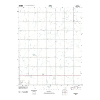
2009 Map of Ringwood
USGS Topo · Published 2009About this map
The town of Ringwood anchors the southwestern corner of this Major County landscape, where the agricultural grid meets the winding tributaries of the Cimarron River watershed. Settled just west of Meno, the area is defined by a methodical system of section-line roads, such as E0360 Rd and N2700 Rd, which navigate the drainage patterns of Turkey Creek and Hoyle Creek. This 2009 survey reveals the persistent presence of early community hubs, marked by several local burial grounds including Saint Michael Cemetery, Union Cemetery, and Pleasant Hill Cemetery. A significant local landmark, the Koehn Lake Dam on Koehn Lake, illustrates the modification of the prairie hydrology for water management. The map reflects a rural Oklahoma economy where the cluster of residences in Ringwood and Meno provides a sharp contrast to the surrounding expanse of farms and riparian corridors like Elm Creek and Indian Creek.
Find a feature on this map
28 named features on this map. Tap any name to fly to it.
Don’t see what you’re looking for? This feature index may not catch every label — zoom into the map to look around manually.
Map Details
Editions of this 2009 Ringwood Map
This is the sole edition of this map. No revisions or reprints were ever made.
Other maps of this area

1955 · Woodward
USGS Topo · 1:250,000

1956 · Ringwood
USGS Topo · 1:62,500

1958 · Woodward
USGS Topo · 1:250,000

1969 · Goltry
USGS Topo · 1:24,000

1969 · Fairview NE
USGS Topo · 1:24,000

1969 · Helena
USGS Topo · 1:24,000

1969 · Fairview SE
USGS Topo · 1:24,000

1969 · Jet SE
USGS Topo · 1:24,000
1982 · Ringwood
USGS Topo · 1:24,000
1982 · Ringwood SW
USGS Topo · 1:24,000