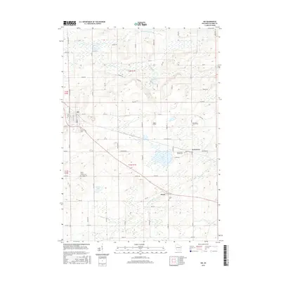
2016 Map of Rio
USGS Topo · Published 2016About this map
Rio and Doylestown serve as primary anchors for this region of Columbia County, Wisconsin, where agricultural lands are defined by a network of drainage systems and small water bodies. The terrain is marked by significant wetlands and slow-moving water, including the Middle Br Duck Cr in the north and the N Br Crawfish River passing through Otsego. Local history and genealogy are deeply rooted in the rural cemetery system, with locations such as the Saint Joseph Cem and Bonnet Prairie Lutheran Cem indicating early settlement patterns and community centers. Transport is dominated by county roads and local connectors like Co RD B and Co RD SS, which link the various hamlets and farms. Small ponds such as Willow Mill Pond and Silver Springs Pond reflect the local hydrology, while the presence of Higgins Airport shows the integration of small-scale aviation into the rural landscape.
Find a feature on this map
82 named features on this map. Tap any name to fly to it.
Don’t see what you’re looking for? This feature index may not catch every label — zoom into the map to look around manually.
Map Details
Editions of this 2016 Rio Map
This is the sole edition of this map. No revisions or reprints were ever made.
Other maps of this area

1901 · Poynette
USGS Topo · 1:62,500

1902 · Portage
USGS Topo · 1:62,500

1955 · Randolph
USGS Topo · 1:62,500

1955 · Columbus
USGS Topo · 1:62,500

1957 · Madison
USGS Topo · 1:250,000

1960 · Madison
USGS Topo · 1:250,000

1962 · Poynette
USGS Topo · 1:62,500

1962 · Portage
USGS Topo · 1:62,500
1980 · North Bristol
USGS Topo · 1:24,000
1980 · Columbus
USGS Topo · 1:24,000