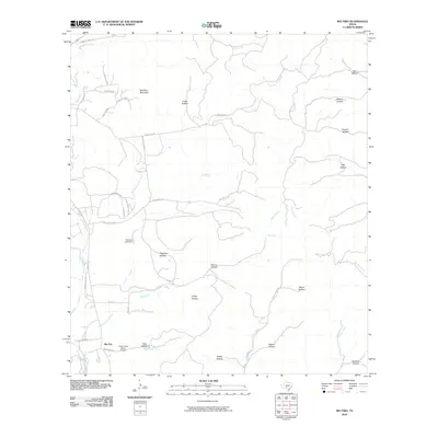
2010 Map of Rio Frio
USGS Topo · Published 2010About this map
Rio Frio serves as the primary settlement in this part of Real County, situated where Deer Creek and the Frio River valley converge. The landscape is defined by a dense network of canyons and family-named hollows, including Friday Hollow, Pole Hollow, and Bailey Hollow, which drain the limestone uplands. Notable elevations like Meridian Mountain and Saddle Mountain punctuate the horizon, while hydrological features such as the Harrison Lake Dam and Mud Spring indicate how water is managed in this arid terrain. Transport is provided by a mix of rural routes like Ranch Rd 337 and specialized access like the Casey Three Ranch Airport, reflecting the region's ranching heritage and isolated residential patterns. The intricate system of waterways, from the East Frio River to Little Dry Frio Creek, dictates the placement of roads and homesteads throughout the quadrangle.
Find a feature on this map
47 named features on this map. Tap any name to fly to it.
Don’t see what you’re looking for? This feature index may not catch every label — zoom into the map to look around manually.
Map Details
Editions of this 2010 Rio Frio Map
This is the sole edition of this map. No revisions or reprints were ever made.
Other maps of this area

1954 · San Antonio
USGS Topo · 1:250,000

1956 · Utopia
USGS Topo · 1:62,500

1957 · San Antonio
USGS Topo · 1:250,000

1957 · York Hollow
USGS Topo · 1:62,500

1960 · Magers Crossing
USGS Topo · 1:24,000

1964 · Circle Bluff
USGS Topo · 1:24,000

1964 · Sabinal Canyon
USGS Topo · 1:24,000
1969 · Vanderpool
USGS Topo · 1:24,000
1969 · Utopia
USGS Topo · 1:24,000
1969 · Rio Frio
USGS Topo · 1:24,000