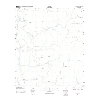
2013 Map of Rio Frio
USGS Topo · Published 2013About this map
The Frio River and E Frio River define the western corridor of this landscape, where the settlements of Leakey and Rio Frio sit along the primary transport routes. This 2013 survey illustrates a region shaped by a dense network of drainage systems, including Little Dry Frio Cr, Deep Cr, and Cherry Cr, which carve through numerous named hollows such as Moore Hollow and Bailey Hollow. The topography is anchored by Meridian Mtn, while water sources like Mud Spring and Panther Springs punctuate the drier stretches of the canyon lands. The road network, including Ranch Road 337 and Cherry Creek Rd, reveals how modern infrastructure follows the natural contours of the Texas Hill Country terrain, connecting scattered ranching properties and remote canyons like Bear Canyon.
Find a feature on this map
50 named features on this map. Tap any name to fly to it.
Don’t see what you’re looking for? This feature index may not catch every label — zoom into the map to look around manually.
Map Details
Editions of this 2013 Rio Frio Map
This is the sole edition of this map. No revisions or reprints were ever made.
Other maps of this area

1954 · San Antonio
USGS Topo · 1:250,000

1956 · Utopia
USGS Topo · 1:62,500

1957 · San Antonio
USGS Topo · 1:250,000

1957 · York Hollow
USGS Topo · 1:62,500

1960 · Magers Crossing
USGS Topo · 1:24,000

1964 · Circle Bluff
USGS Topo · 1:24,000

1964 · Sabinal Canyon
USGS Topo · 1:24,000
1969 · Vanderpool
USGS Topo · 1:24,000
1969 · Utopia
USGS Topo · 1:24,000
1969 · Rio Frio
USGS Topo · 1:24,000