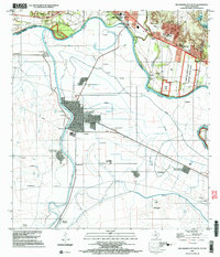
2002 Map of Rio Grande City South
USGS Topo · Published 2003About this map
The Rio Grande Bravo serves as a winding international boundary in this 2002 survey of the borderlands between Starr County, Texas, and Tamaulipas, Mexico. The landscape is dominated by the sprawling Lower Rio Grande Valley National Wildlife Refuge, which provides a significant buffer along the river's northern banks. This map is particularly notable for its detailed coverage of both sides of the border, featuring the Mexican city of Camargo and the smaller Nuevo Camargo, alongside the Estación Camargo rail site. On the American side, Rio Grande City is anchored by U.S. Customs and the Puente de Cuota Aduana, emphasizing the cross-border transit that defines this region's economy. The map also identifies the Monumento Batalla Santa Gertrudis to the south, highlighting the area's complex military and revolutionary history.
Find a feature on this map
66 named features on this map. Tap any name to fly to it.
Don’t see what you’re looking for? This feature index may not catch every label — zoom into the map to look around manually.
Map Details
Editions of this 2002 Rio Grande City South Map
This is the sole edition of this map. No revisions or reprints were ever made.
Other maps of this area

1949 · Mc Allen
USGS Topo · 1:250,000

1954 · McAllen
USGS Topo · 1:250,000

1956 · Garcias
USGS Topo · 1:62,500

1956 · Los Ebanos
USGS Topo · 1:62,500

1956 · Escobares
USGS Topo · 1:62,500

1957 · Mc Allen
USGS Topo · 1:250,000

1962 · McAllen
USGS Topo · 1:250,000

1965 · Rio Grande City South
USGS Topo · 1:24,000

1965 · Los Garzas
USGS Topo · 1:24,000

1965 · La Grulla
USGS Topo · 1:24,000