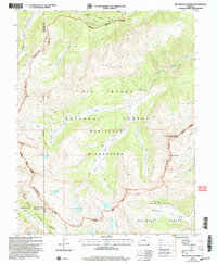
2001 Map of Rio Grande Pyramid
USGS Topo · Published 2005About this map
The Continental Divide snake-like through this high-altitude landscape of Hinsdale County, anchoring a terrain defined by massive peaks and glacial basins. Rising prominently in the southeast, the Rio Grande Pyramid stands as a primary landmark near the iconic geological formation known as The Window. This region is a major hydrological headwaters area, where the Rio Grande begins its descent, fed by a network of high-elevation tributaries including Sweetwater Creek and Ute Creek.
Find a feature on this map
37 named features on this map. Tap any name to fly to it.
Don’t see what you’re looking for? This feature index may not catch every label — zoom into the map to look around manually.
Map Details
Editions of this 2001 Rio Grande Pyramid Map
This is the sole edition of this map. No revisions or reprints were ever made.
Other maps of this area

1897 · Silverton
USGS Topo · 1:62,500

1900 · Needle Mountains
USGS Topo · 1:62,500

1901 · Silverton
USGS Topo · 1:62,500

1902 · Needle Mountains
USGS Topo · 1:62,500

1902 · Silverton
USGS Topo · 1:62,500

1905 · San Cristobal
USGS Topo · 1:125,000

1907 · San Cristobal
USGS Topo · 1:125,000

1945 · Durango
USGS Topo · 1:250,000

1953 · Durango
USGS Topo · 1:250,000

1954 · Durango
USGS Topo · 1:250,000