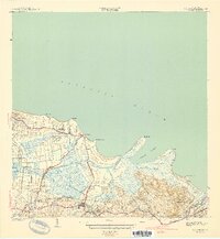
1941 Map of Rio Grande
USGS Topo · Published 1941About this map
Agricultural colonies and coastal settlements define this northeast Puerto Rican shoreline as surveyed in the late 1930s. The landscape is characterized by the convergence of river systems like the Rio Espiritu Santo and Rio Herrera with the Atlantic Ocean, creating a network of tidal channels and lagoons such as the Ensenada Comezon. Sugarcane production is evident through numerous named agricultural estates, including Colonia Dolores, Colonia Carmelita, and Colonia Blasina, which are interspersed with residential hubs like Poblado Honduras and Poblado Mediania Alta. The town of Rio Grande serves as a primary inland anchor, while smaller sidings and points of interest such as Desvio Dolores and Desvio Carmelita suggest the logistical movements of the local sugar economy before mid-century modernization transformed the region.
Find a feature on this map
39 named features on this map. Tap any name to fly to it.
Don’t see what you’re looking for? This feature index may not catch every label — zoom into the map to look around manually.
Map Details
Editions of this 1941 Rio Grande Map
2 editions found
Other maps of this area

1940 · Carolina
USGS Topo · 1:30,000

1941 · Rio Grande
USGS Topo · 1:30,000

1941 · Carolina
USGS Topo · 1:30,000

1945 · El Yunque
USGS Topo · 1:30,000

1946 · El Yunque
USGS Topo · 1:30,000

1946 · Gurabo
USGS Topo · 1:30,000

1946 · Fajardo
USGS Topo · 1:30,000

1947 · Carolina
USGS Topo · 1:30,000

1947 · El Yunque NE
USGS Topo · 1:10,000

1947 · Gurabo NE
USGS Topo · 1:10,000