
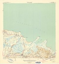
1941 Map of Rio Grande
USGS Topo · Published 1941About this map
Rio Grande sits at the heart of this coastal survey, where the river of the same name meets the Atlantic Ocean at Boca Herrera. The landscape is defined by the transition from the upland peaks of Cerro Bravo and Cerro El Faro down to the extensive wetlands of Cienaga La Picua. Along the coast, a series of prominent headlands including Pta Miquillo and Pta Picua shelter the waters of Ensenada Comezon.
Find a feature on this map
42 named features on this map. Tap any name to fly to it.
Don’t see what you’re looking for? This feature index may not catch every label — zoom into the map to look around manually.
Map Details
Editions of this 1941 Rio Grande Map
2 editions found
Other maps of this area

1940 · Carolina
USGS Topo · 1:30,000

1941 · Carolina
USGS Topo · 1:30,000

1945 · El Yunque
USGS Topo · 1:30,000

1946 · El Yunque
USGS Topo · 1:30,000

1946 · Gurabo
USGS Topo · 1:30,000

1946 · Fajardo
USGS Topo · 1:30,000

1947 · Carolina
USGS Topo · 1:30,000

1947 · El Yunque NE
USGS Topo · 1:10,000

1947 · Gurabo NE
USGS Topo · 1:10,000

1947 · Rio Grande
USGS Topo · 1:30,000