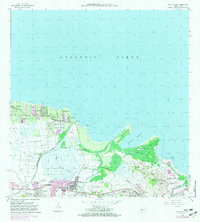
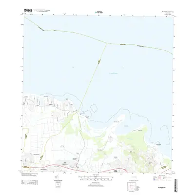
1947 Map of Rio Grande
USGS Topo · Published 1950About this map
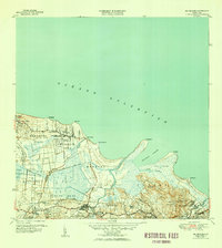
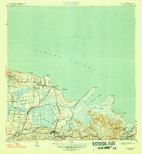
Agricultural colonies and coastal wetlands define this northern Puerto Rican landscape during the late 1940s. The settlement of Río Grande sits inland, south of the extensive Ciénaga La Picúa and the waters of Ensenada Comezón. The map documents a transition from the marshy lowlands of Medianía Baja to the higher elevations of Mameyes II, punctuated by numerous named agricultural estates such as Colonia Mini Mini and Colonia Fortuna.
Find a feature on this map
48 named features on this map. Tap any name to fly to it.
Don’t see what you’re looking for? This feature index may not catch every label — zoom into the map to look around manually.
Map Details
Editions of this 1947 Rio Grande Map
3 editions found

Historical Maps of Río Grande Through Time
20 maps found

1941 Rio Grande
Río Grande Municipio, PR

1945 El Yunque
Río Grande Municipio, PR

1946 El Yunque
Río Grande Municipio, PR
1947 El Yunque NE
Río Grande Municipio, PR
1947 El Yunque NO
Río Grande Municipio, PR
1947 El Yunque SO
Río Grande Municipio, PR
1947 Rio Grande
Río Grande Municipio, PR

1949 Rio Grande SO
Río Grande Municipio, PR

1950 Rio Grande SE
Río Grande Municipio, PR

1952 El Yunque
Río Grande Municipio, PR

1956 Rio Grande
Río Grande Municipio, PR

1958 El Yunque
Río Grande Municipio, PR
1963 Rio Grande
Río Grande Municipio, PR
1967 El Yunque
Río Grande Municipio, PR
2013 El Yunque
Río Grande Municipio, PR
2013 Rio Grande
Río Grande Municipio, PR
2018 El Yunque
Río Grande Municipio, PR
2018 Rio Grande
Río Grande Municipio, PR

2024 El Yunque
Río Grande Municipio, PR

2024 Rio Grande
Río Grande Municipio, PR