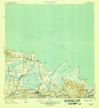
1947 Map of Rio Grande
USGS Topo · Published 1947About this map
The coastal landscapes of Medianía Baja and Medianía Alta define this northeast Puerto Rican corridor during the late 1930s and early 1940s. The agricultural character of the region is evident through the numerous colonias that dot the alluvial plains, such as Colonia Dolores, Colonia Blasina, and Colonia Miñi. These estates are connected by a network of canals, including Canal Juan and Canal Angela, which manage the water from the Río Grande and Quebrada de las Lajas as they flow toward the Océano Atlántico.
Find a feature on this map
45 named features on this map. Tap any name to fly to it.
Don’t see what you’re looking for? This feature index may not catch every label — zoom into the map to look around manually.
Map Details
Editions of this 1947 Rio Grande Map
3 editions found

Other maps of this area

1940 · Carolina
USGS Topo · 1:30,000

1941 · Rio Grande
USGS Topo · 1:30,000

1941 · Carolina
USGS Topo · 1:30,000

1945 · El Yunque
USGS Topo · 1:30,000

1946 · El Yunque
USGS Topo · 1:30,000

1946 · Gurabo
USGS Topo · 1:30,000

1946 · Fajardo
USGS Topo · 1:30,000

1947 · Carolina
USGS Topo · 1:30,000

1947 · El Yunque NE
USGS Topo · 1:10,000

1947 · Gurabo NE
USGS Topo · 1:10,000