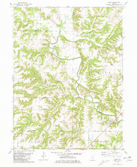
1981 Map of Ripley
USGS Topo · Published 1981About this map
The La Moine River winds through the borderlands of Schuyler and Brown counties, carving a deep valley that defines the local geography. Near the settlement of Ripley, the industrial character of the late twentieth century is evidenced by a Claypit and a Gaging Station, while the local economy's older roots are marked by Scotts Mill further upstream. The landscape is heavily dissected by tributaries like Missouri Creek, Horney Branch, and North Fork Shelby Creek, creating numerous isolated ridges such as West Ridge.
Find a feature on this map
32 named features on this map. Tap any name to fly to it.
Don’t see what you’re looking for? This feature index may not catch every label — zoom into the map to look around manually.
Map Details
Editions of this 1981 Ripley Map
This is the sole edition of this map. No revisions or reprints were ever made.
Other maps of this area

1923 · Rushville
USGS Topo · 1:62,500

1926 · Rushville
USGS Topo · 1:62,500

1926 · Mt Sterling
USGS Topo · 1:62,500

1928 · Meredosia
USGS Topo · 1:62,500

1929 · Mt Sterling
USGS Topo · 1:62,500

1931 · Meredosia
USGS Topo · 1:62,500

1946 · Augusta
USGS Topo · 1:62,500

1948 · Quincy
USGS Topo · 1:250,000

1949 · Augusta
USGS Topo · 1:62,500

1956 · Quincy
USGS Topo · 1:250,000