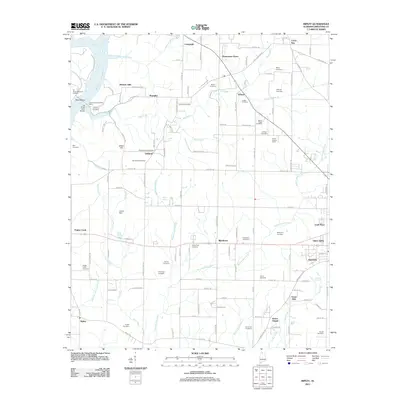
2011 Map of Ripley
USGS Topo · Published 2011About this map
O'Neal Lookout Tower stands as a prominent landmark in the rolling terrain of Limestone County, where the Elk River meets a network of vital northern Alabama waterways. This 2011 survey illustrates a landscape defined by small crossroads settlements and family legacies, tracing the winding paths of Big Creek, Round Island Creek, and Sugar Creek. The map provides significant genealogical value through its density of documented burial sites, including the Farrow, Yarbrough, and Crenshaw cemeteries, which often sit near vanished school sites or early farmsteads. Cultural and recreational life is anchored by landmarks like the Sportsmans Park Fish Camp and Turner Chapel, while the river infrastructure at Elk River Mills Bridge and the Littrell Dam on Dry Creek reveals the historical importance of water management and crossing points in the growth of communities like Shanghai, Oakland, and Blackburn.
Find a feature on this map
135 named features on this map. Tap any name to fly to it.
Don’t see what you’re looking for? This feature index may not catch every label — zoom into the map to look around manually.
Map Details
Editions of this 2011 Ripley Map
This is the sole edition of this map. No revisions or reprints were ever made.
Other maps of this area

1888 · Huntsville
USGS Topo · 1:125,000

1892 · Huntsville
USGS Topo · 1:125,000

1935 · Athens
USGS Topo · 1:24,000

1936 · Union Hill
USGS Topo · 1:24,000

1936 · Stewart Cross Roads
USGS Topo · 1:24,000

1936 · Elkmont
USGS Topo · 1:24,000

1936 · Ripley
USGS Topo · 1:24,000

1936 · Hillsboro
USGS Topo · 1:24,000

1936 · Tanner
USGS Topo · 1:24,000

1936 · Cairo
USGS Topo · 1:24,000