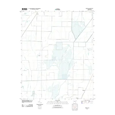
2011 Map of Risher
USGS Topo · Published 2011About this map
Walker Cemetery sits as a quiet landmark within a landscape defined by an intricate network of drainage and natural waterways in Poinsett County. This 2011 survey illustrates the managed hydrology of the Arkansas Delta, where agricultural fields are serviced by engineered channels like Farley Ditch, Elm Ditch, and the lengthy Long Pond Or Cache Ditch. These man-made features intersect with older natural patterns such as Gum Slough and Maple Slough, revealing how the low-lying terrain has been adapted for cultivation. Small settlements and rail sidings like Risher and McDaniel are positioned along the transport corridors north of Weiner, while the broad wetland area known as Ash Spread indicates the persisting marshy character of the bottomlands near Big Creek.
Find a feature on this map
48 named features on this map. Tap any name to fly to it.
Don’t see what you’re looking for? This feature index may not catch every label — zoom into the map to look around manually.
Map Details
Editions of this 2011 Risher Map
This is the sole edition of this map. No revisions or reprints were ever made.
Other maps of this area

1935 · Sedgwick
USGS Topo · 1:62,500

1935 · Alicia
USGS Topo · 1:62,500

1935 · Tuckerman
USGS Topo · 1:62,500

1939 · Weiner
USGS Topo · 1:62,500

1953 · Memphis
USGS Topo · 1:250,000

1956 · Memphis
USGS Topo · 1:250,000

1959 · Weiner
USGS Topo · 1:62,500

1959 · Sedgwick
USGS Topo · 1:62,500

1960 · Weiner
USGS Topo · 1:62,500
1960 · Sedgwick
USGS Topo · 1:62,500