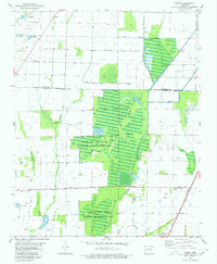
1980 Map of Risher
USGS Topo · Published 1980About this map
The lowlands of Poinsett County are defined by a complex network of waterways and managed wetlands, most notably the Bayou De View State Wildlife Management Area. This landscape, centered between the Cache River and Bayou DeView, is crisscrossed by numerous sloughs such as Tupelo Slough, Maple Slough, and Gum Slough. These natural drainage patterns are supplemented by an extensive system of ditches and floodgates, supporting a regional economy tied to irrigation and wildlife conservation.
Find a feature on this map
21 named features on this map. Tap any name to fly to it.
Don’t see what you’re looking for? This feature index may not catch every label — zoom into the map to look around manually.
Map Details
Editions of this 1980 Risher Map
This is the sole edition of this map. No revisions or reprints were ever made.
Other maps of this area

1935 · Sedgwick
USGS Topo · 1:62,500

1935 · Alicia
USGS Topo · 1:62,500

1935 · Tuckerman
USGS Topo · 1:62,500

1939 · Weiner
USGS Topo · 1:62,500

1953 · Memphis
USGS Topo · 1:250,000

1956 · Memphis
USGS Topo · 1:250,000

1959 · Weiner
USGS Topo · 1:62,500

1959 · Sedgwick
USGS Topo · 1:62,500

1960 · Weiner
USGS Topo · 1:62,500
1960 · Sedgwick
USGS Topo · 1:62,500