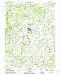
1992 Map of Rising Sun
USGS Topo · Published 1993About this map
The historical Mason and Dixon Line serves as the focal point of this 1990s-era survey, where the border between Maryland and Pennsylvania bisects a landscape defined by rolling countryside and colonial-era legacies. At the heart of the map is Rising Sun, a prominent crossroads town supported by landmarks like West Nottingham Academy and the regional infrastructure of the Philadelphia Wilmington and Baltimore RR.
Find a feature on this map
65 named features on this map. Tap any name to fly to it.
Don’t see what you’re looking for? This feature index may not catch every label — zoom into the map to look around manually.
Map Details
Editions of this 1992 Rising Sun Map
This is the sole edition of this map. No revisions or reprints were ever made.
Other maps of this area

1898 · Elkton
USGS Topo · 1:62,500

1900 · Elkton
USGS Topo · 1:62,500

1900 · Havre De Grace
USGS Topo · 1:62,500

1904 · Coatesville
USGS Topo · 1:62,500

1906 · Coatesville
USGS Topo · 1:62,500

1912 · Quarryville
USGS Topo · 1:62,500

1917 · Elkton
USGS Topo · 1:62,500

1918 · Coatesville
USGS Topo · 1:62,500

1942 · Havre De Grace
USGS Topo · 1:62,500

1942 · Elkton
USGS Topo · 1:62,500
Featured Places
- Little Britain Township, PA
- Rising Sun, MD
- Mount Pleasant Acres, MD
- Mount Pleasant Manor, MD
- West Nottingham Township, PA