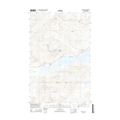
2014 Map of Rising Sun
USGS Topo · Published 2014About this map
Saint Mary Lake dominates the central landscape of this high-altitude region, serving as the focal point for the early 21st-century infrastructure within Glacier National Park. The alignment of the Going To The Sun Rd traces the northern shoreline, providing access to the developed area at Rising Sun and the prominent Going-to-the-Sun Point. This corridor is defined by its engineering and natural landmarks, including the Baring Creek Bridge and the dramatic Sunrift Gorge. Away from the main road, the terrain is marked by a network of drainage systems and glacial features such as Rose Basin and The Narrows. Significant summits like Little Chief Mtn and Otokomi Mtn tower over alpine water bodies including Otokomi Lake and Red Eagle Lake, while numerous cascades like Baring Falls and Virginia Falls illustrate the active hydrology of the Continental Divide's eastern slopes.
Find a feature on this map
36 named features on this map. Tap any name to fly to it.
Don’t see what you’re looking for? This feature index may not catch every label — zoom into the map to look around manually.
Map Details
Editions of this 2014 Rising Sun Map
This is the sole edition of this map. No revisions or reprints were ever made.
Other maps of this area

1901 · Browning
USGS Topo · 1:125,000

1903 · Browning
USGS Topo · 1:125,000

1904 · Chief Mountain
USGS Topo · 1:125,000

1938 · Chief Mountain
USGS Topo · 1:125,000

1960 · Cut Bank
USGS Topo · 1:250,000

1963 · Cut Bank
USGS Topo · 1:250,000

1964 · Cut Bank
USGS Topo · 1:250,000

1968 · Saint Mary
USGS Topo · 1:24,000

1968 · Babb
USGS Topo · 1:24,000
1968 · Cut Bank Pass
USGS Topo · 1:24,000