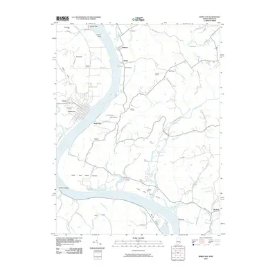
2010 Map of Rising Sun
USGS Topo · Published 2010About this map
Rising Sun and Rabbit Hash face one another across a sweeping bend of the Ohio River, anchoring a landscape defined by fertile river bottoms and deep-rooted family history. The topography transitions from the low-lying Upper East Bend Bottom and Mexico Bottom to the higher elevations of Henschen Hill and Mead Ridge. This area is dense with family and community burial grounds, including the LaGrange Cemetery, Pope Cemetery, and Marshall Cemetery, offering a detailed resource for genealogical research. The presence of Laughery Island and the confluence of several large tributaries like Lick Creek and Gunpowder Creek illustrate the historical importance of the river corridor for both transport and agriculture. Small settlements such as Waterloo, McVille, and Belleview dot the higher ground above the river's floodplain, connected by rural routes like Victory Schoolhouse Rd and Rabbit Hash Hill Rd.
Find a feature on this map
86 named features on this map. Tap any name to fly to it.
Don’t see what you’re looking for? This feature index may not catch every label — zoom into the map to look around manually.
Map Details
Editions of this 2010 Rising Sun Map
This is the sole edition of this map. No revisions or reprints were ever made.
Other maps of this area

1914 · West Cincinnati
USGS Topo · 1:62,500

1915 · Lawrenceburg
USGS Topo · 1:48,000

1928 · Lawrenceburg
USGS Topo · 1:62,500

1932 · Lawrenceburg
USGS Topo · 1:62,500

1943 · Florence
USGS Topo · 1:24,000

1943 · Aberdeen
USGS Topo · 1:24,000

1943 · Aurora
USGS Topo · 1:24,000

1943 · Rising Sun
USGS Topo · 1:24,000

1943 · Lawrenceburg
USGS Topo · 1:24,000

1943 · Patriot
USGS Topo · 1:24,000