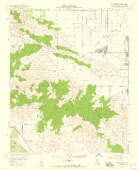
1958 Map of Ritter Ridge
USGS Topo · Published 1959About this map
San Andreas Rift Zone geology dominates the landscape of this late 1950s survey, marking a distinct trench between Ritter Ridge and the southern Sierra Pelona range. The map illustrates a transitional era for the High Desert as the settlement of Palmdale begins expanding westward near Lake Palmdale. Amidst the sagebrush and canyons, traces of the region’s hard-rock mining history remain visible in the southwestern corner, featuring the Puritan Mine, Red Rover Mine, and Governor Mine. Traditional agricultural and ranching lifestyles are represented by long-established sites like Messer Ranch and Tuckerway Ranch, even as modern infrastructure like the Hauser Microwave Sta and the burgeoning Antelope Valley Country Club signify the coming suburban shift. The drainage patterns of Amargosa Creek and Anaverde Creek provide the primary hydrological structure for the surrounding valley floor.
Find a feature on this map
39 named features on this map. Tap any name to fly to it.
Don’t see what you’re looking for? This feature index may not catch every label — zoom into the map to look around manually.
Map Details
Editions of this 1958 Ritter Ridge Map
3 editions found
Other maps of this area

1900 · Tujunga
USGS Topo · 1:62,500

1900 · Fernando
USGS Topo · 1:62,500

1901 · Southern California Sheet No. 1
USGS Topo · 1:250,000

1904 · Southern California Sheet No. 1
USGS Topo · 1:250,000

1915 · Elizabeth Lake
USGS Topo · 1:125,000

1917 · Elizabeth Lake
USGS Topo · 1:125,000

1930 · Ravenna
USGS Topo · 1:24,000

1930 · Lancaster
USGS Topo · 1:24,000

1931 · Del Sur
USGS Topo · 1:24,000

1932 · Red Rover
USGS Topo · 1:24,000