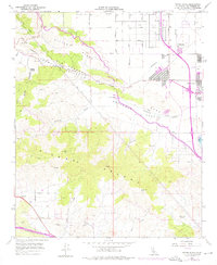
1958 Map of Ritter Ridge
USGS Topo · Published 1975About this map
The high desert landscape of Sierra Pelona and the Anaverde Valley is defined by the critical infrastructure and mining activity of the mid-20th century. The California Aqueduct snakes across the northern slopes of Ritter Ridge, utilizing specialized engineering features like the Ritter Siphon and Leona Siphon to move water through the arid terrain. While the emerging city of Palmdale occupies the eastern edge near Lake Palmdale, the surrounding canyons remain a network of family-named settlements and industrial sites. In the southern reaches, several historical mining operations are clearly marked, including the Puritan Mine, Red Rover Mine, and Governor Mine. These sites, along with isolated outposts like Messer Ranch and City Ranch, provide a detailed record of land use and resource extraction in Los Angeles County before the full weight of modern suburban expansion reached this portion of the Antelope Valley.
Find a feature on this map
31 named features on this map. Tap any name to fly to it.
Don’t see what you’re looking for? This feature index may not catch every label — zoom into the map to look around manually.
Map Details
Editions of this 1958 Ritter Ridge Map
3 editions found
Other maps of this area

1900 · Tujunga
USGS Topo · 1:62,500

1900 · Fernando
USGS Topo · 1:62,500

1901 · Southern California Sheet No. 1
USGS Topo · 1:250,000

1904 · Southern California Sheet No. 1
USGS Topo · 1:250,000

1915 · Elizabeth Lake
USGS Topo · 1:125,000

1917 · Elizabeth Lake
USGS Topo · 1:125,000

1930 · Ravenna
USGS Topo · 1:24,000

1930 · Lancaster
USGS Topo · 1:24,000

1931 · Del Sur
USGS Topo · 1:24,000

1932 · Red Rover
USGS Topo · 1:24,000