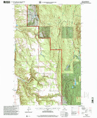
1996 Map of Ritz
USGS Topo · Published 1999About this map
Kaniksu National Forest dominates the high ground of the Idaho Panhandle in this late-twentieth-century study of Boundary County. The terrain is defined by a steep descent from the forest heights toward the lower agricultural lands of the North Bench. In this transition zone, the small settlement of Ritz is situated along Fleming Creek, while the Deer Park Community Hall serves as a localized landmark for the surrounding rural community. The map reveals a history of resource extraction and local hydrology, noting several prospects and the Regal Mine tucked into the northern slopes. Water management and natural drainage are evident in the cluster of wetlands on the eastern side, including Smith Lake, Deer Lake Swamp, and Bonner Swamp, which are fed by numerous seasonal runs like Templeman Creek and Meadow Creek.
Find a feature on this map
27 named features on this map. Tap any name to fly to it.
Don’t see what you’re looking for? This feature index may not catch every label — zoom into the map to look around manually.
Map Details
Editions of this 1996 Ritz Map
This is the sole edition of this map. No revisions or reprints were ever made.
Other maps of this area

1911 · Priest Lake
USGS Topo · 1:250,000

1913 · Priest Lake
USGS Topo · 1:250,000

1958 · Sandpoint
USGS Topo · 1:250,000

1963 · Sandpoint
USGS Topo · 1:250,000

1965 · Meadow Creek
USGS Topo · 1:24,000

1965 · Farnham Peak
USGS Topo · 1:24,000

1965 · Eastport
USGS Topo · 1:24,000

1965 · Moravia
USGS Topo · 1:24,000

1965 · Ritz
USGS Topo · 1:24,000

1965 · Copeland
USGS Topo · 1:24,000