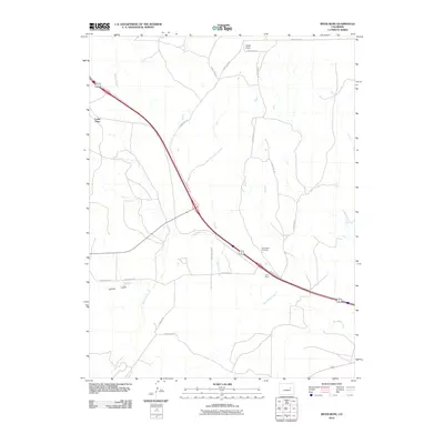
2010 Map of River Bend
USGS Topo · Published 2010About this map
Big Sandy Creek winds across this Elbert County landscape, defining the topography near the small settlement of River Bend. The map illustrates a rural junction where high-plains geography meets a critical transportation corridor, with the River Bend Cemetery serving as a local landmark for genealogical research. To the northwest, the elevated terrain of Cedar Point overlooks the drainage of Beaver Creek, while the southern reaches are marked by Willow Gulch and Resolis Rd. This 2010 survey provides a clear view of the county road network, including County Hwy-118, showing how modern infrastructure follows the natural paths carved by the area's intermittent waterways.
Find a feature on this map
16 named features on this map. Tap any name to fly to it.
Don’t see what you’re looking for? This feature index may not catch every label — zoom into the map to look around manually.
Map Details
Editions of this 2010 River Bend Map
This is the sole edition of this map. No revisions or reprints were ever made.
Other maps of this area

1891 · Limon
USGS Topo · 1:125,000

1892 · Limon
USGS Topo · 1:125,000

1954 · Limon
USGS Topo · 1:250,000

1957 · Limon
USGS Topo · 1:250,000

1958 · Limon
USGS Topo · 1:250,000

1970 · Agate
USGS Topo · 1:24,000
1970 · Matheson
USGS Topo · 1:24,000
1970 · Beuck Draw
USGS Topo · 1:24,000

1970 · Limon
USGS Topo · 1:24,000

1970 · Four Corners
USGS Topo · 1:24,000