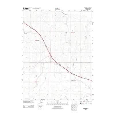
2013 Map of River Bend
USGS Topo · Published 2013About this map
River Bend and the surrounding high plains of Elbert County are defined by a landscape where modern transportation corridors follow the ancient paths carved by seasonal water. Big Sandy Creek flows southeast across the lower half of the quadrangle, joined by drainage from Willow Gulch and Beaver Cr. The modern path of Interstate 70 and Us-24 E cuts a dominant diagonal across the terrain, reflecting the area's continued role as a gateway through the Colorado plains. Genealogists and local historians can locate the River Bend Cem positioned just north of the highway, while the prominent landform of Cedar Point stands as a landmark in the northwestern corner of the sheet. The map also detail a network of rural routes such as Resolis Rd and numerous county roads that provide access to the dispersed agricultural holdings of this region.
Find a feature on this map
23 named features on this map. Tap any name to fly to it.
Don’t see what you’re looking for? This feature index may not catch every label — zoom into the map to look around manually.
Map Details
Editions of this 2013 River Bend Map
This is the sole edition of this map. No revisions or reprints were ever made.
Other maps of this area

1891 · Limon
USGS Topo · 1:125,000

1892 · Limon
USGS Topo · 1:125,000

1954 · Limon
USGS Topo · 1:250,000

1957 · Limon
USGS Topo · 1:250,000

1958 · Limon
USGS Topo · 1:250,000

1970 · Agate
USGS Topo · 1:24,000
1970 · Matheson
USGS Topo · 1:24,000
1970 · Beuck Draw
USGS Topo · 1:24,000

1970 · Limon
USGS Topo · 1:24,000

1970 · Four Corners
USGS Topo · 1:24,000