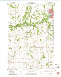
1974 Map of River Falls West
USGS Topo · Published 1977About this map
River Falls sits at the northeastern edge of this mid-1970s survey, where the Kinnickinnic River winds through deep ravines and scenic valleys before meeting the St. Croix. The western expansion of the city is visible near Glen Park and the local Jr High Sch, showing a community integrated with its riverfront geography. To the south and west, the landscape shifts into the agricultural plateaus of Clifton and Oak Grove townships, punctuated by family-named landmarks like Mann Valley and local burial grounds including Greenwood Valley Cem.
Find a feature on this map
36 named features on this map. Tap any name to fly to it.
Don’t see what you’re looking for? This feature index may not catch every label — zoom into the map to look around manually.
Map Details
Editions of this 1974 River Falls West Map
This is the sole edition of this map. No revisions or reprints were ever made.
Other maps of this area

1944 · Red Wing
USGS Topo · 1:62,500

1946 · Hudson
USGS Topo · 1:62,500

1946 · River Falls
USGS Topo · 1:62,500

1949 · River Falls
USGS Topo · 1:62,500

1949 · Hudson
USGS Topo · 1:62,500

1949 · Hudson
USGS Topo · 1:24,000

1950 · Hudson
USGS Topo · 1:24,000

1951 · Prescott
USGS Topo · 1:24,000

1952 · Red Wing
USGS Topo · 1:62,500

1953 · Saint Paul
USGS Topo · 1:250,000