
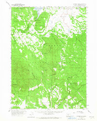
1960 Map of Riverbed Butte
USGS Topo · Published 1961About this map
Sycan Marsh and the Sycan River dominate this high-desert landscape within the Fremont National Forest and Winema National Forest. The map documents a transition from early resource extraction to mid-century forest management, evidenced by the trace of an Old Logging Railroad winding through The Basin and past Horse Glade. Remote outposts and family-named landmarks like McCartie Ranch, Griffin Ranch, and the Sycan Fire Guard Sta provide essential data points for local genealogists and historians tracking settlement in the Lake and Klamath county borderlands. Numerous water sources, including Frying Pan Spring, Watkins Spring, and Meryl Reservoir, define the locations of these early homesteads and grazing lands.
Find a feature on this map
52 named features on this map. Tap any name to fly to it.
Don’t see what you’re looking for? This feature index may not catch every label — zoom into the map to look around manually.
Map Details
Editions of this 1960 Riverbed Butte Map
2 editions found
Other maps of this area

1889 · Klamath
USGS Topo · 1:250,000

1894 · Klamath
USGS Topo · 1:250,000

1955 · Klamath Falls
USGS Topo · 1:250,000

1958 · Klamath Falls
USGS Topo · 1:250,000

1960 · Sycan Marsh
USGS Topo · 1:62,500

1960 · Bly
USGS Topo · 1:62,500

1960 · Beatty
USGS Topo · 1:62,500

1960 · Fuego Mountain
USGS Topo · 1:62,500

1960 · Fishhole Mtn
USGS Topo · 1:62,500

1960 · Yamsay Mountain
USGS Topo · 1:62,500